Prosser Airport &
Pilot Information

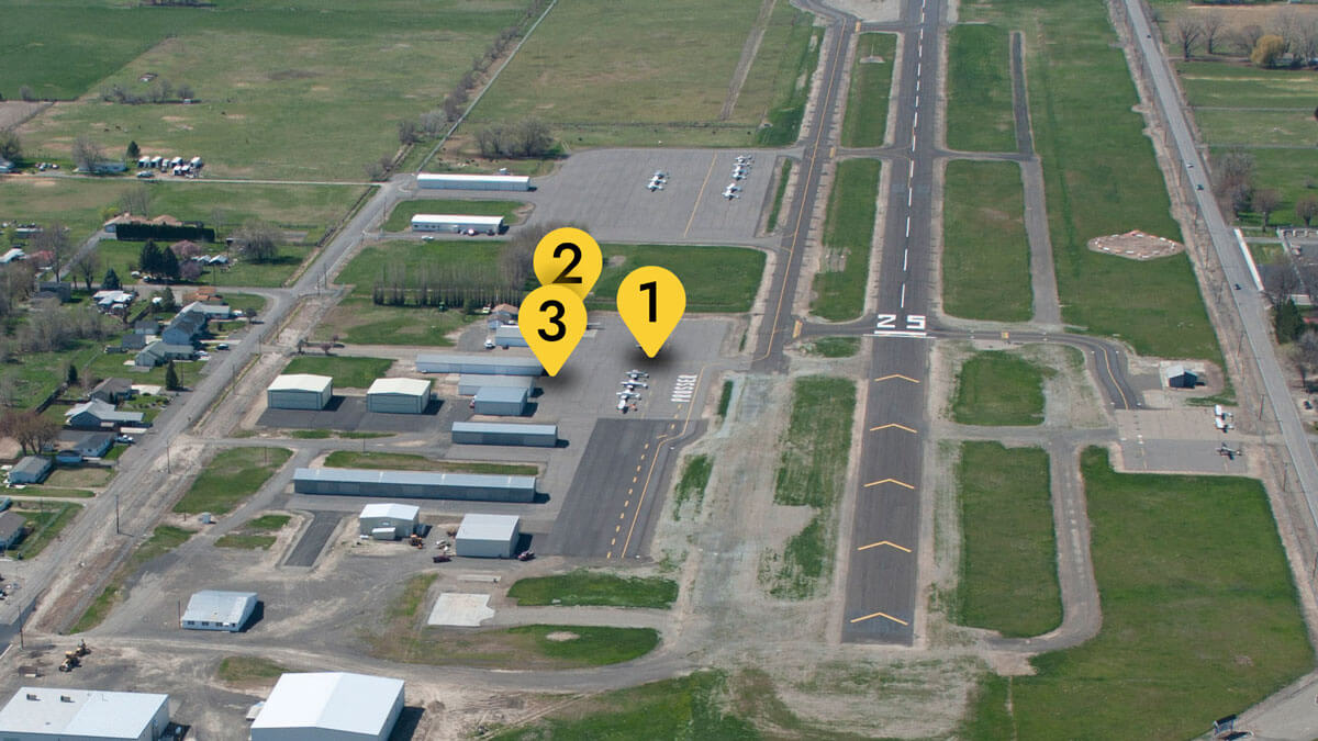
- 1. Tie Downs
- 2. Fuel
- 3. Pilot Lounge
The Prosser Airport serves the general aviation community, including regional agriculture and business aviation customers who need air transportation options close to their operations. Prosser Airport has a paved runway, a fixed base operator, fuel and other amenities with nearby interstate access.
Pilot & Airport Information Prosser Airport (S40)
Weather
Automated Weather Observing System (AWOS)
An Automated Weather Observing System is in place at the Prosser Airport. You can access this information by phone: 509-786-8889 or by frequency 121.125 MHz.
Fuel
Pilot Lounge
The pilot lounge is open during normal business hours. After hours it has a numeric keylock number that can be obtained through the Pasco Airport Tower.
- Free Wi-Fi
- Phone
- Lounge area
- Restroom
- Restaurants nearby
Hangar & Tie Downs Information
Hangars: For lease information and rates or if you are interested in building a hangar at the airport, contact the Airport Manager.
Tie Downs: The Prosser Airport has 65 tie-downs and a no-fee policy for up to seven days. There are no landing fees or terminal use fees.
Mechanical & Other Services
- Transient Storage: Tie Down
- Airframe Repairs: None
- Powerplant Repairs: None
- Other Services: None
- Bulk Oxygen: None
- Bottle Oxygen: None
Contact
Quentin Wright
Airport Manager
Major Projects
Public Meeting
Wednesday, July 10
5 p.m.
2140 Wine Country Road, Prosser
Longitude & Latitude
Physical Address
111 Nunn Road
Prosser, WA 99350
Plans & Policy Documents
2022 Approved Policies and Standard Leases
Bid Opportunities
Public Notices
The operator is responsible for ensuring that all Federal Aviation Administration (FAA) regulations and Washington state laws are followed. Each time you consider a flight, be sure to:
- Check the FAA website for rule and guidance updates for Unmanned Aircraft Systems (UAS)
- Know the three main steps to fly under 14 CRF Part 107
- Review the Know Before You Fly campaign
- Review FAA’s Hot Topics and FAQs
- Download the FAA’s B4UFLY app or other industry mapping apps for the UAS user
Please see the updated FAA guidance below for UAS flights near the airport.
Airports in Uncontrolled Airspace
For flights near airports in uncontrolled airspace that remain under 400’ above the ground, prior authorization is not required. When flying in these areas, remote pilots and recreational flyers must be aware of and avoid traffic patterns and takeoff and landing areas. A drone must not interfere with operations at the airport must yield right-of-way to all other aircraft. Uncontrolled airspace and other flying restrictions can be found on our B4UFLY app.
Obstruction evaluations are vital to keeping air traffic operations safe. These evaluations apply to all construction taking place at the airport, and many projects outside the airport. Obstruction evaluations often apply to buildings, antennas, towers, cranes (even temporary) and other structures that have the potential to interfere with airspace, aircraft approaches and ground equipment located at the airport.
If you have questions regarding your project, please contact the Airport Manager at 509-375-3060.
According to 14 CFR Part 77.9, any person or organization must notify the FAA Administrator if they intend to sponsor any of the following construction or alterations:
- Construction or alteration exceeding 200 feet above ground level
- Construction or alteration:
- Within 20,000 feet of a public use or military airport which exceeds a 100:1 surface from any point on the runway of each airport with its longest runway more than 3,200 feet
- Within 10,000 feet of a public use or military airport that exceeds a 50:1 surface from any point on the runway of each airport with its longest runway no more than 3,200 feet
- Within 5,000 feet of a public use heliport that exceeds a 25:1 surface
- Highway, railroad or other traverse way whose prescribed adjusted height would exceed the above-noted standards
- When requested by the FAA
- Construction or alteration located on a public-use airport or heliport regardless of height or location
Visit the FAA’s Obstruction Evaluation / Airport Airspace Analysis webpage for more information regarding whether or not you will need to file FAA Form 7460-1.
Additional information can be found on the Washington State Department of Transportation obstruction evaluation webpage.
To learn more about the Port’s Disadvantaged Business Enterprise Program, visit our Disadvantaged Business Enterprises webpage.
NOTICE
Port of Benton’s FY 2021-2023 Disadvantaged Business Enterprises goal for the Prosser Airport is 2.17% DBE Participation to be obtained through 2.17% race-neutral and 0.00% race-conscious means.
A copy of the DBE goal and the calculations used to determine this goal may be obtained by contacting Bryan Condon, Century West Engineering at bcondon@centurywest.com


